ARC GIS - Staff Presentation
ICT Showcase & Share, July 18th 2006
ARC GIS
Presenter: Tim Clemens
Geographic inquiry and geographic information systems (GIS) are important in assisting educators, students, and their institutions to answer personal and community questions with local to global implications. GIS in the classroom helps foster critical thinking and problem solving, 21st century workforce skills, and citizenship and community participation among young people and educators.

During Geography classes at Gippsland Grammar in 2006 there have been a number of innovations. The most important of these has been the introduction of Arcmap 9.1. This is one of the latest Geographic Information Systems (GIS) software packages. GIS is used by many companies in Australia and overseas, for planning and development. It is also used by government and educational departments, to provide a hands-on tool for the creation of maps and for the analysis of geographic information. In schools it allows students to learn about this new technology whilst investigating the world around them.
In Year 11 we have completed a study of the world’s tectonic plates and their effect on humans using Arcmap 9.1. The software allowed students to map the locations of earthquakes and volcanic eruptions for a specific year and to look for the relationships between them. It was also then possible to identify the cities in the world most at risk from major earthquake damage or volcanic eruptions. Another aspect of the study was to examine the processes that create and cause these events in order to understand the formation and characteristics of volcanic environments, as part of Unit One of the VCE course for Geography.
In Year 12 students used the software to compare the population structures of countries around the world, including examples from Europe, Africa and Australia. This allowed the students to then examine the factors leading to the similarities and differences found during this task.
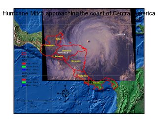
Year 10’s also used the software to investigate the causes and effects of hurricanes and cyclones. They examined the case study of Hurricane Mitch in Central America in order to evaluate why this Hurricane was so deadly compared to others in the region. This involved the use of satellited images, rainfall data, windspeed data and maps of the regions infrastructure and population.
I am looking forward to further developing innovative and engaging units of work using this software and incorporating all the latest technology available and in doing so develop within the students an understanding of the world around them and of their role in its management.
If you would like to learn more about this program, please don't hesitate to contact Tim.
